STUDIES ON HYBRID POSITIONING METHODS
Background
The present European Radio Navigation Plan (ERNP, 1996) calls for research, technical development and demonstration (RTD&D) to support a future radio navigation systems mix. The sensitivity of the radio navigation signals to jamming and unintentional interference is an especially important issue to be considered when satellite-based systems (GPS, GLONASS and the planned Galileo GNSS) are used for safety critical applications. These satellite signals are weak and employ ultra-high frequencies (UHF) which provide a good geographical coverage and accuracy but at the expense of reception reliability. On the other hand ground-based transmitters (Loran-C, Radio and Radar Beacons, etc.) emit radio signals of much higher power in the low (LF), medium (MF) or some high frequency (HF) bands which generally results in a more secure reception of such signals.
Until recently, the radio navigation policy of the United States was to terminate their terrestrial radio navigation networks in the near future, with a view to using GPS as the backbone of navigational systems. The uncertain situation resulting from this approach has prevented the navigation industry from making long-term plans on optimal uses of different navigation aids (NAVAID).
The US Department of Transportation has now made a decision to continue their Loran-C radio navigation service well beyond year 2000. Demands are rapidly growing for cheap hybrid navigation receivers that fully exploit advantages of all different navigational aids of the near future, with consequential requirements to make new RTD&D analyses on the best possible mixes of these systems from the European point of view.
K- Filtering
The theory on K- Filtering (KF) was established in the early 1960's. Since then all digital navigation and piloting systems have relied on the KF computations due to their most stringent safety and reliability requirements. However, automatic Guidance, Navigation and Control (GN&C) systems of the near future are becoming increasingly sophisticated. These new developments are posing computational difficulties to the conventional method of KF computing. Meteorologists were the first to face this problem of "1000 Crays working in tandem" (Tzvi Gal-Chen, Bull. Am. Met. Soc., Vol. 71, No. 5, May 1990, page 684).
The Fast K- Filter (FKF)
A exceptionally fast KF computing method for very large systems was discovered in 1989 at the Finnish Meteorological Institute, Helsinki, Finland. This algorithm is known as the Fast K- Filter (FKF). Mathematicians consider it improbable that any simpler and faster alternative solution for optimal KF computing could still be found as the FKF algorithm is semi-analytical. The original research work in this area arose as part of a need to improve the radio location computations for signal data acquired by the WMO/Vaisala balloon tracking systems during the Global Weather Experiment in 1978-1979 (Jatila, 1996).
Applications
A navigation receiver is expected to become a compulsory part of every mobile phone from 2001 onwards. However, existing navigation technology is not easily applied to small pocket, wrist or head devices as the need to save battery power calls for special processors and algorithms. These considerations suggest that a simple navigation receiver is used and that signals from only one network are utilised. A simple navigational solution would indeed minimize many complexities of the KF computations. However, such systems cannot detect and correct local anomalies of the navigation signals and the computed positional information can thus be inaccurate or unavailable. The reliability of a navigation system is improved only by calibrating the receiver using signals from many sources and analyzing their simultaneous time series. At present these expensive hybrid navigation receivers are primarily used by commercial and tactical aircraft as their conventional KF algorithms need much computing and battery power.
LORAN-C chains
LOng RANge radio navigation network C comprises several independent chains of transmitters. Each chain has 2-6 stations transmitting pulsed signals at the 100 kHz carrier frequency. All chains are synchronised to the Universal Time Coordinated (UTC). This makes it possible to use "cross-chain" navigation receivers for the combined world coverage shown in Figure 1. This is the nominal navigational coverage that reaches out only to areas where clean ground-wave pulses of the Loran-C signals can be received from any three transmitting stations:
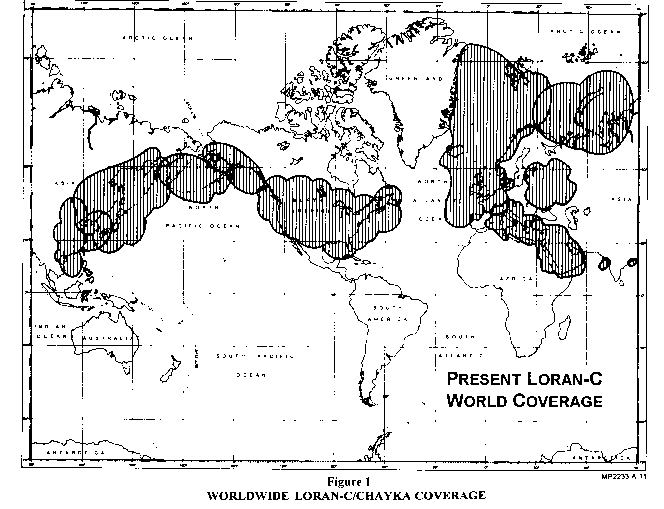
More distant (about 1000 km) Loran-C signals suffer from sky-wave interference but the relative (or differential) positioning accuracy is quite seldom degraded below requirements of observing systems. In fact, Loran-C signals can be usable up to 2000 km from transmitting stations, i.e. far beyond navigational coverage. However, the Geometric Dilution Of Precision (GDOP) may become so severe that it totally or occasionally prevents Loran-C from being used as a sole means of positioning.
Combinations of different signals and sensors are exploited in maritime, aeronautical and space applications for improving bad GDOP situations. However, such hybrid systems are sensitive to inconsistencies caused by systematic errors in subsystems. A minor calibration drift may create grossly misleading positional information. The FKF approach offers a computational breakthrough that is needed for cheap hybrid K- Filtering (Lange, 1990a). Figure 2 below intends to give a rough idea of how distant Loran-C signals could offer useful information on relative positions when employed in combination with other navigational aids like GPS signals:
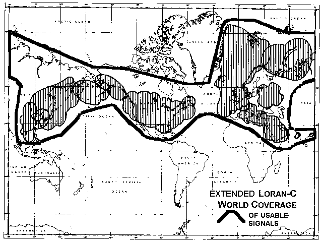
Figure 2
Envisaged extended coverage of usable Loran-C signals
Many new automated GN&C systems are expected to benefit from hybrid uses of the Loran-C chains or other local radio networks emitting phase-stable signals by exploiting sophisticated calibration methods. Their coverage can be extended over the whole European continent e.g. for the following applications:
All other omputational and hardware obstacles are swiftly being removed from the path towards cheap navigation receivers of high reliability and accuracy. Such hybrid receivers will, in the long run, exploit all available sources of positional information and not only signals from one or two navigation satellite systems (GPS, GLONASS or GNSS). This method also makes it possible to obtain reliable real-time estimates (Rao, 1972) of the actual positioning accuracies that vary much depending on circumstances.
Proposal
This pilot project aims at studying optimal mixes of different positioning methods that can be employed by mobile/portable navigation receivers of observing and public service systems. A new search will be made into currently available navigational aids (Lange, 1985) and different radio transmission networks emitting phase-stable signals. The FKF and MINQUE (Minimum Norm Quadratic Unbiased Estimation) algorithms will be used for preparing preliminary coverage and/or accuracy maps of a number of promising mixes for Europe. Industrial companies will make equipment available for field tests.
Reference is made to FKF.net.BIBLIOGRAPHY